
Geospatial Imagery Analytics Market By Type(Video-Based Analytics, Imagery Analytics), By Deployment Type(Cloud, On-Premises), By End-User Type(Environment Monitoring, Government, others), By Region And Companies - Industry Segment Outlook, Market Assessment, Competition Scenario, Trends, And Forecast 2023-2032
-
12690
-
Jul 2023
-
337
-


-
This report was compiled by Vishwa Gaul Vishwa is an experienced market research and consulting professional with over 8 years of expertise in the ICT industry, contributing to over 700 reports across telecommunications, software, hardware, and digital solutions. Correspondence Team Lead- ICT Linkedin | Detailed Market research Methodology Our methodology involves a mix of primary research, including interviews with leading mental health experts, and secondary research from reputable medical journals and databases. View Detailed Methodology Page
-
Quick Navigation
Report Overview
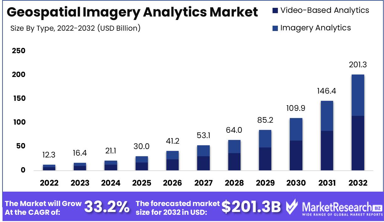
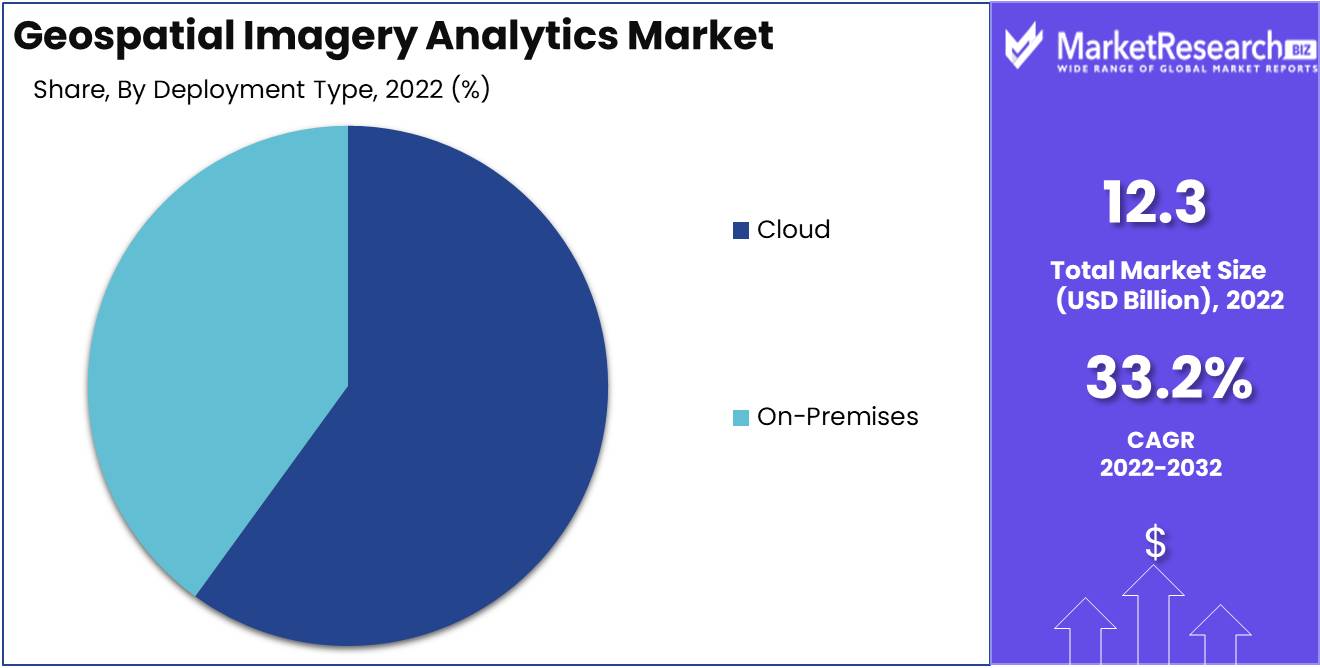
Geospatial Imagery Analytics Market size is expected to be worth around USD 201.3 Bn by 2032 from USD 12.3 Bn in 2022, growing at a CAGR of 33.2% during the forecast period from 2023 to 2032.
The research report on the Geospatial Imagery Analytics Market is a deep dive into this dynamic market. It uses geospatial information and cutting-edge technologies to find tactical and strategic insights. Using the power of satellite and aerial imagery, it creates detailed mapping data that can be used in many different areas, such as planning infrastructure, taking care of the environment, and making digital media. The utilization of geospatial data analytics has become a very important tool for both government agencies and private businesses. This is because their decisions are based on geospatial data that is rich in images.
As a new idea in technology, the Geospatial Imagery Analytics Market is quickly spreading to many different areas. It is based on getting insights from geospatial data, especially satellite imagery, which allows a shift in the way decisions are made. By making a picture of a certain area, this new method reveals complex patterns, shows what the main trends are, and finds strange things that are hard to see in other ways. In today's fast-paced world, such revolutionary technology has truly revolutionized how companies and governments work.
The most important thing about Geospatial Imagery Analytics is that it allows for live mapping of physical and geometric terrains with a level of accuracy that is unmatched. As a result, it makes it easier to build strong infrastructure, respond quickly to disasters, measure environmental damage, and improve agriculture. In addition, its worth goes beyond these areas and spreads to many others, including travel and tourism, logistics, government and urban planning, marketing, and many others.
Driving factors
Advancements in Geospatial Analytics Technologies
The advancements in generative ai in geospatial analytics technologies are one of the main reasons that drive the geospatial analytics market. With these technologies, service providers can analyze geospatial data and get insights that can be used to make smart choices.
Technologies for geospatial analytics, like geographic information systems (GIS), remote sensing, and LiDAR, are developing at a rate that is unheard of. These technologies are becoming more and more important in a wide range of fields, such as planning cities and running transportation systems.
Having More Satellite Images Available
High-resolution satellite images are becoming more and more common, which is also a big driver of the geospatial imagery analytics market. With the development of satellite imagery, it is now possible to get very thorough information about things like terrain, vegetation, and urban areas.
This has given businesses and organizations that need geospatial information to make decisions new ways to do business. For instance, insurance companies can now use satellite imagery to figure out how much damage natural disasters have caused.
Demand for Insights That Can Be Used
One of the main things driving the geospatial imagery analytics market is the demand for useful insights. Now that there is more geospatial data available, businesses and organizations are looking for quick ways to get useful insights.
Machine learning and artificial intelligence are two examples of advanced geospatial analytics technologies that have made it possible to handle huge amounts of data quickly. These technologies can find trends and connections in data, which helps businesses make decisions that are well-informed.
Restraining Factors
Limited Access to High-Quality and Up-To-Date Imagery
For geospatial image analytics, it's important to have access to high-quality and up-to-date imagery, but it's not always easy to get. This is due to a number of factors, including limited satellite coverage, a lack of facilities for collecting data, and cost constraints. Businesses or organizations that need geospatial imagery data may have trouble obtaining it, which makes it harder for them to do good data analysis.
But because technology has recently gotten better, the market now has many services that give access to high-quality satellite imagery and other useful data. Organizations' ability to obtain the necessary data is improved by the availability of open-source data.
Problems with Computation
The rise of geospatial imagery analytics has also been slowed by problems with computation. For a precise study of geospatial data, you need to do a lot of complicated math and have a lot of computing power. Because the data is so complicated, standard ways of computing and software are not good for Geospatial Image Analytics.
However the development of specialized software like geographic information systems (GIS) and geospatial data analysis tools has made it easier to deal with these problems. The development of these tools has changed geospatial image analytics by making it possible for analysts to process large amounts of data in less time and with more accuracy.
Type Analysis
The video-based analytics Segment dominates the Geospatial Imagery Analytics Market. The Video-Based Analytics Segment dominates the market for Geospatial Imagery Analytics. The technology uses high-resolution cameras that record videos in real time. These videos are then processed to find useful information. Real-time video research is useful in a number of industries, including transportation, defense, and security.
Video-based analytics assist in locating specific areas of interest, which helps to ensure safety generally. As a potential tool for reducing traffic-related issues in urban areas, the technology aids in identifying alternative routes. Additionally, video-based analytics features technology can be used to evaluate critical infrastructure projects, which assist in assessing progress and ensuring quality control.
Due to the burgeoning economies of developing economies, the adoption of the Video-Based Analytics Segment is accelerating. Several countries around the world have put in a lot of money to improve their transportation systems, like China with its intelligent traffic management systems and India with its improved public monitoring systems.
The governments of these economies are working to improve urban facilities and modernize transportation, which is helping the market grow steadily. Growing development and urbanization have led to more traffic jams, accidents, and crimes, which has increased the need for Geospatial Imagery Analytics, especially in the Video-Based Analytics Segment.
Deployment Type Analysis
The technology is now being used more and more for Geospatial Imagery Analytics, and Cloud Computing has made major changes in many other fields. Because it offers a cheap way to centrally manage big amounts of data, the Cloud Segment dominates the Geospatial Imagery Analytics Market. The technology is useful for improving speed because it makes it easy to add more users quickly and gives reliable security measures. The cloud-based systems provide a variety of features, including advanced data analytics, real-time monitoring, and quick data processing, among others, making the technology useful for a variety of industry sectors.
Due to the fast growth of economies in emerging markets, the Cloud Segment adoption is increasing greatly. To increase productivity and cut costs, governments in many different countries are promoting the adoption of cloud-based options. The adaptability provided by cloud computing is useful for improving the performance of various industrial sectors, including agriculture, building, and transportation, among others, which leads to lower operational costs. The security of cloud-based systems has also been improved, which is important in industries like defense and security.
End-User Type Analysis
As a result of the technology's ability to analyze environmental factors like soil quality, vegetation, temperature, and pollution, among others, the Environment Monitoring Segment dominates the Geospatial Imagery Analytics Market. The technology is useful in many fields, including agriculture, forestry, mining, and protecting the environment.
The technology works on different features, such as precision agriculture, environmental mapping, and monitoring, which assist in making the best use of resources and lowering operational costs. Monitoring environmental factors is useful for identifying natural disasters, which helps to lessen the effects of disasters and keep people safe.
The fast growth of economies in developing markets is driving the adoption of the Environment Monitoring Segment in a big way. Different countries' governments are taking steps to modernize the agriculture and forestry sectors, which is a big reason why the market is growing.
Precision agriculture and forestry management systems are aiding in resource optimization and cost reduction. Similar systems are also useful in the mining and environmental protection industries. Monitoring environmental factors is also aiding various governments around the world in predicting natural disasters and preparing for them as needed.
Key Market Segments
By Type
- Video-Based Analytics
- Imagery Analytics
By Deployment Type
- Cloud
- On-Premises
By End-User Type
- Environment Monitoring
- Government
- Defense & Security
- Engineering & Construction
- Mining & Manufacturing
- Agriculture
- Insurance
- Healthcare
- Energy, Utility, and Natural Resources
- Others
Growth Opportunity
Defense Sector
For the Geospatial Imagery Analytics Market, the defense sector offers a sizable growth potential. With growing worries about global security, defense organizations are using geospatial analytics to improve situational awareness, intelligence gathering, and mission planning. When defense agencies can analyze and understand geospatial data in real-time, they can learn important things that help them make decisions and run their operations better.
Agriculture Industry
Geospatial imagery analytics has significant growth opportunities in the farm sector. Farmers can learn more about crop health, soil conditions, and water use by using satellite imagery and geospatial data. This lets them make the best use of their resources, use precision farming methods, and make well-informed decisions to boost crop yield and cut costs. Geospatial analytics can also help keep track of pest problems, evaluate farm conditions, and use fertilizers and pesticides most effectively.
Logistics and Transportation
A promising growth possibility for geospatial imagery analytics is the transportation and logistics sector. With supply lines getting more complicated and the need for better route planning, geospatial analytics can help logistics operations run more smoothly. It lets businesses look at traffic patterns, keep an eye on road conditions, and make choices based on data to improve fleet management, cut down on delivery times, and improve operational efficiency as a whole.
Latest Trends
Increasing Use of Satellite Imagery for Geospatial Analysis
Satellite imagery has become an important part of geospatial analysis because it shows the whole area of the Earth from above. Satellite imagery is a good way to collect geospatial data over a big area that would be hard or impossible to get from the ground. It makes it possible to take very clear and accurate pictures of places like forests, oceans, and polar regions that are typically difficult to get to.
To identify ways to reduce the impact of their operations on the ecosystems around them, businesses can use satellite imagery to assess environmental targets. Mining companies can use this technology to assess the impact of their operations on the environment. So, it's no surprise that the use of satellite imagery is on the rise, and we should expect it to remain an important tool for geospatial research.
Integration of AI and Machine Learning in Geospatial Analytics
AI and machine learning have become important parts of data processing. With these technologies, correlations, and patterns in big data sets can be found that would be difficult to find otherwise. Through Machine Learning, we can make algorithms that learn from the data sets and can process these huge amounts of valuable data that would be nearly impossible for people to analyze.
AI and machine learning are used in geospatial analytics to identify image patterns and extract useful data from big data sets. It is important to be able to identify and track changes in things like deforestation, illegal mining, natural disasters, and hurricane cleanup.
Also, many businesses that use data analytics are turning to AI for predictive analysis. This type of analysis uses machine learning to predict how things will go in the future. We can identify better forecasting models and make more accurate predictions when geospatial analytics and AI are combined.
Rise of Detailed Analysis Based on High-Resolution Aerial Images
The most important source of data for geospatial research is now aerial imagery. High-resolution aerial imagery lets users analyze areas with an accuracy of just a few centimeters, making it ideal for projects that need a clear picture of the area.
High-resolution aerial imagery is being used in a variety of fields, including building, real estate, agriculture, and insurance. Businesses can evaluate the size of real estate properties, potential development opportunities, or even crop growth prospects in a specific area. Governments and cities can plan more thorough urbanization projects and infrastructure improvements thanks to the high accuracy of the data given by high-resolution aerial imagery.
Regional Analysis
Geographic information systems (GIS), remote sensing, and machine learning technologies are combined in geospatial imagery analytics. It uses tools like satellites, planes, and drones to gather data, which is then processed and shown in a way that helps people make better decisions. Geospatial analytics solutions give companies real-time insights and accurate data that help them understand complex spatial connections and make smart decisions.
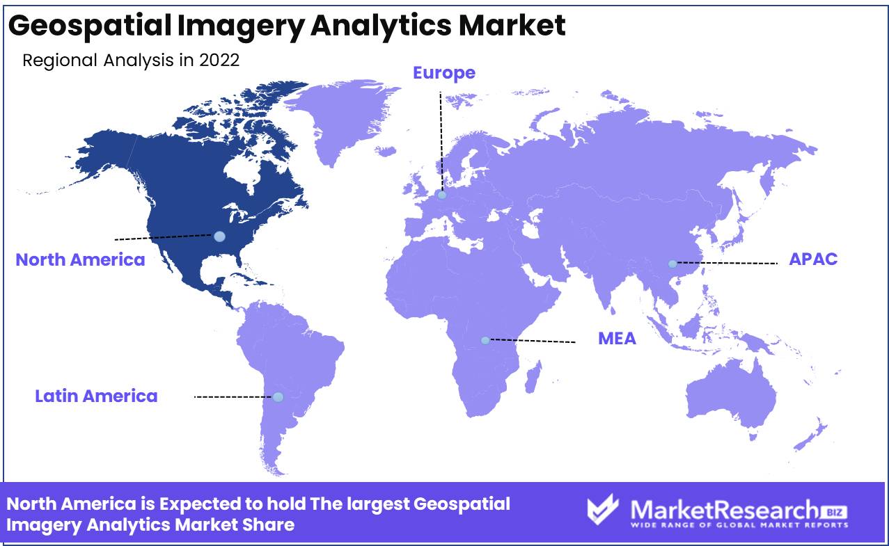
The market for geospatial photo analytics is currently led by North America. This is because of a number of things. First, North America has a very advanced ecosystem of geospatial analytics service providers, startups, and established companies. This has helped the region become the leader in the geospatial analytics market, with companies like Esri, Harris Geospatial Solutions, and DigitalGlobe leading the way.
There are many sources of geospatial data in North America. Satellite, airborne, and drone-based sensor systems in the region are very advanced and can take detailed images and data sets. With the introduction of 5G, IoT, and AI technologies, the region will continue to be at the top when it comes to creating geospatial data.
Key Regions and Countries
North America
- US
- Canada
- Mexico
Western Europe
- Germany
- France
- The UK
- Spain
- Italy
- Portugal
- Ireland
- Austria
- Switzerland
- Benelux
- Nordic
- Rest of Western Europe
Eastern Europe
- Russia
- Poland
- The Czech Republic
- Greece
- Rest of Eastern Europe
APAC
- China
- Japan
- South Korea
- India
- Australia & New Zealand
- Indonesia
- Malaysia
- Philippines
- Singapore
- Thailand
- Vietnam
- Rest of APAC
Latin America
- Brazil
- Colombia
- Chile
- Argentina
- Costa Rica
- Rest of Latin America
Middle East & Africa
- Algeria
- Egypt
- Israel
- Kuwait
- Nigeria
- Saudi Arabia
- South Africa
- Turkey
- United Arab Emirates
- Rest of MEA
Key Players Analysis
DigitalGlobe gives its customers access to high-resolution satellite imagery and geospatial data. The company has been a top player in the market because of its advanced imaging technology, which makes it possible to understand geospatial data in a thorough and accurate way.
Trimble Inc. is a major geospatial technology company that offers advanced positioning solutions and integrated software for collecting, analyzing, and showing geospatial information. The company's solutions have been used in a wide range of fields, from building and agriculture to transportation and utilities.
Harris Corporation's geospatial solutions provide data and analytics for a wide range of businesses, such as defense and intelligence, transportation, and energy. Customers can make well-informed choices thanks to the solutions offered by the company.
ESRI Inc. has been a leader in the market for geospatial analytics by giving customers software solutions that let them see, evaluate, and share geospatial data. The company's ArcGIS platform is used by a wide range of businesses, such as government, utilities, and natural resources.
Top Key Players in the Geospatial Imagery Analytics Market
- Alphabet Inc. (Google Inc.)
- DigitalGlobe
- Jacobs Engineering Group Inc. (KeyW Corporation)
- L3Harris Technologies Inc. (Harris Geospatial Solutions, Inc.)
- Hexagon AB
- Trimble Inc.
- Maxar Technologies Inc.
- Fugro NV
- Environmental Systems Research Institute Inc. (Esri)
- Here Technologies
- Planet Labs Inc.
- UrtheCast Corp.
- Orbital Insight Inc.
Recent Development
- In 2022, Planet Labs announced the launch of its high-tech PlanetScope platform, which was made to track changes in the environment. With this cutting-edge technology, customers can collect geospatial data with a high level of accuracy and precision.
- In 2022, DigitalGlobe's new geospatial imagery analytics tool, DigitalGlobe Explore, will also be released. Geospatial analytics technology has undergone a major advancement thanks to DigitalGlobe Explore's cutting-edge visualization and analysis features.
- In 2023, The launch of Maxar Oberon, a new geospatial analytics platform for imagery, has been announced by Maxar Technologies. This new software will change the business world by noticing and tracking changes in the surroundings.
- In 2023, BlackSky has announced that its new geospatial imagery analytics platform, BlackSky SkySat Analytics, will be available. With the help of this potent tool, geospatial data can be tracked and analyzed more effectively, giving people priceless information about the changes happening around them.
Report Scope
Report Features Description Market Value (2022) USD 12.3 Bn Forecast Revenue (2032) USD 201.3 Bn CAGR (2023-2032) 33.2% Base Year for Estimation 2022 Historic Period 2016-2022 Forecast Period 2023-2032 Report Coverage Revenue Forecast, Market Dynamics, COVID-19 Impact, Competitive Landscape, Recent Developments Segments Covered By Type(Video-Based Analytics, Imagery Analytics), By Deployment Type(Cloud, On-Premises), By End-User Type(Environment Monitoring, Government, Defense & Security, Engineering & Construction) Regional Analysis North America – The US, Canada, & Mexico; Western Europe – Germany, France, The UK, Spain, Italy, Portugal, Ireland, Austria, Switzerland, Benelux, Nordic, & Rest of Western Europe; Eastern Europe – Russia, Poland, The Czech Republic, Greece, & Rest of Eastern Europe; APAC – China, Japan, South Korea, India, Australia & New Zealand, Indonesia, Malaysia, Philippines, Singapore, Thailand, Vietnam, & Rest of APAC; Latin America – Brazil, Colombia, Chile, Argentina, Costa Rica, & Rest of Latin America; Middle East & Africa – Algeria, Egypt, Israel, Kuwait, Nigeria, Saudi Arabia, South Africa, Turkey, United Arab Emirates, & Rest of MEA Competitive Landscape Alphabet Inc. (Google Inc.), DigitalGlobe, Jacobs Engineering Group Inc. (KeyW Corporation), L3Harris Technologies Inc. (Harris Geospatial Solutions, Inc.), Hexagon AB, Trimble Inc., Maxar Technologies Inc., Fugro NV, Environmental Systems Research Institute Inc. (Esri), Here Technologies, Planet Labs Inc., UrtheCast Corp., Orbital Insight Inc. Customization Scope Customization for segments, region/country-level will be provided. Moreover, additional customization can be done based on the requirements. Purchase Options We have three licenses to opt for: Single User License, Multi-User License (Up to 5 Users), Corporate Use License (Unlimited User and Printable PDF) -
-
- Alphabet Inc. (Google Inc.)
- Jacobs Engineering Group Inc. (KeyW Corporation)
- L3Harris Technologies Inc. (Harris Geospatial Solutions, Inc.)
- Hexagon AB
- Trimble Inc.
- Maxar Technologies Inc.
- Fugro NV
- Environmental Systems Research Institute Inc. (Esri)
- Here Technologies
- Planet Labs Inc.
- UrtheCast Corp.
- Orbital Insight Inc.
Our Clients


View Our Licence Options
