
Geographic Information System (GIS) Market By Component (Hardware, Software), By Function (Mapping, Surveying, Telematics Navigation, Location-Based Services), By Device Type (Desktop, Mobile), By End-User (Transport and Logistics, Agriculture, Construction, Mining and Geology, Oil & Gas, Others), By Region and Companies - Industry Segment Outlook, Market Assessment, Competition Scenario, Trends and Forecast 2024-2033
-
1522
-
July 2024
-
165
-


-
This report was compiled by Vishwa Gaul Vishwa is an experienced market research and consulting professional with over 8 years of expertise in the ICT industry, contributing to over 700 reports across telecommunications, software, hardware, and digital solutions. Correspondence Team Lead- ICT Linkedin | Detailed Market research Methodology Our methodology involves a mix of primary research, including interviews with leading mental health experts, and secondary research from reputable medical journals and databases. View Detailed Methodology Page
-
Quick Navigation
Report Overview
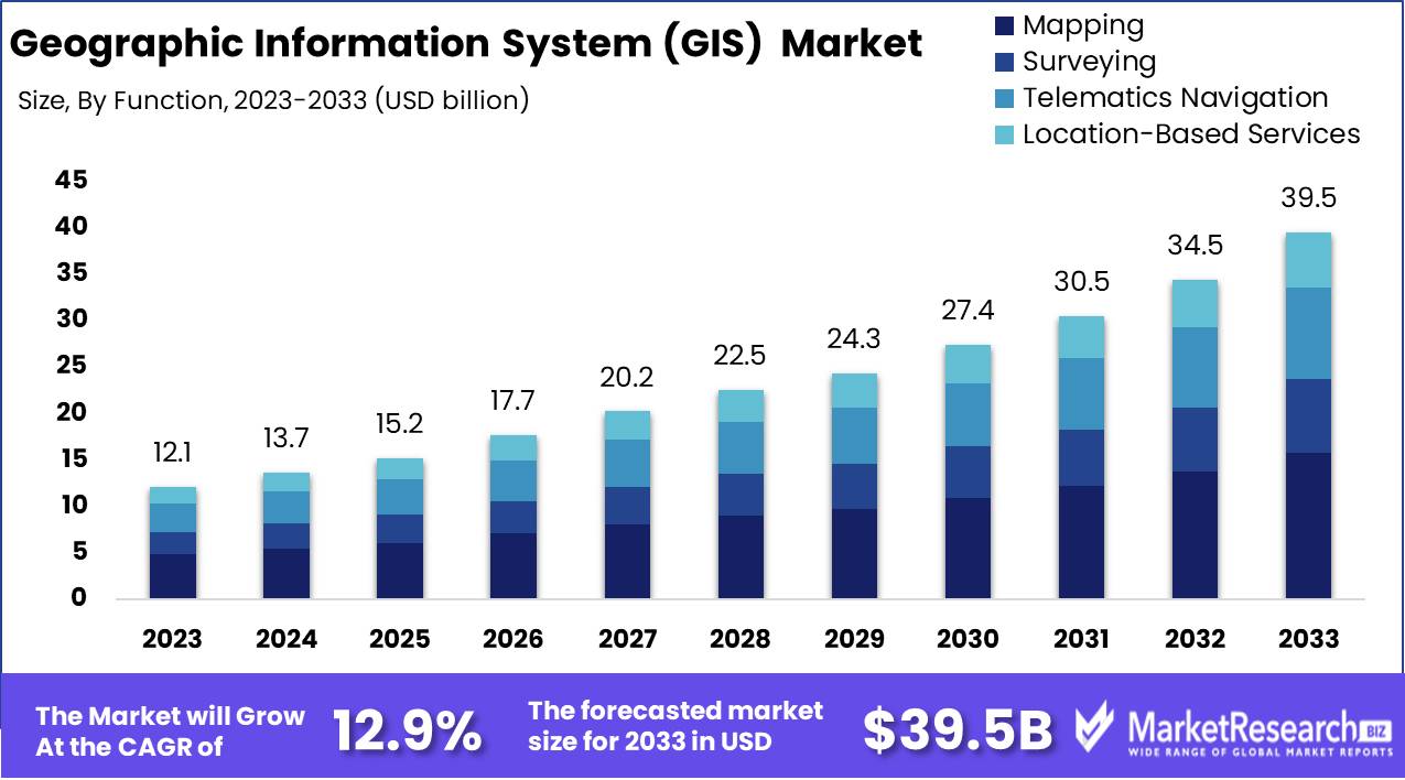
The Global Geographic Information System (GIS) Market was valued at USD 12.1 Bn in 2023. It is expected to reach USD 39.5 Bn by 2033, with a CAGR of 12.9% during the forecast period from 2024 to 2033.
The Geographic Information System (GIS) market encompasses technologies and tools used to capture, store, analyze, manage, and present spatial or geographic data. GIS integrates hardware, software, and data for mapping and analyzing real-world phenomena. It aids decision-making across various sectors, including urban planning, transportation, environmental management, and public safety.
By visualizing complex data sets, GIS enables users to identify patterns, relationships, and trends, fostering more informed and strategic decisions. The market is driven by the growing need for spatial data integration, advancements in technology, and increasing applications in location-based services, infrastructure development, and disaster management.
The Geographic Information System (GIS) market has evolved significantly since its inception in the 1960s, primarily driven by technological advancements and pioneering efforts by companies like Esri. Early applications of spatial analysis, such as John Snow's 1854 cholera map, underscore the foundational principles that continue to drive the market today. Modern GIS technology has expanded its reach across various sectors, offering robust solutions for complex spatial data integration and analysis. The integration of GIS with other technological advancements, such as the Internet of Things (IoT), artificial intelligence (AI), and cloud computing, is revolutionizing its application and utility.
A notable example of GIS efficacy is observed in a university's deployment of a mobile GIS platform using ArcPad software on 50 PocketPC devices. This initiative enabled campus security and emergency response teams to access geographic data directly in the field, resulting in a 30% faster response to incidents. Such case studies highlight the transformative impact of GIS on operational efficiency and decision-making processes.
The GIS market's growth trajectory is further bolstered by its diverse applications across urban planning, environmental management, transportation, and public safety. The demand for real-time data analysis and the integration of location-based services are key drivers propelling market expansion. The increasing need for disaster management and infrastructure development is accelerating GIS adoption. As organizations continue to recognize the strategic value of spatial data, the GIS market is poised for substantial growth, characterized by innovation and expanding applications across various industries.
Key Takeaways
- Market Growth: The Global Geographic Information System (GIS) Market was valued at USD 12.1 Bn in 2023. It is expected to reach USD 39.5 Bn by 2033, with a CAGR of 12.9% during the forecast period from 2024 to 2033.
- By Component: Hardware accounts for 60% of the market, essential for the robust performance and data processing required by GIS applications.
- By Function: Mapping functions dominate, making up 40%, crucial for visualizing geographic data across various industries.
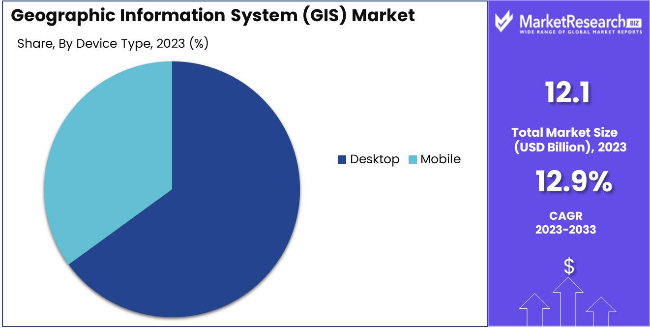
- By Device Type: Desktop systems lead with 65%, preferred for their powerful processing capabilities and extensive usability.
- By End-User: Transport and Logistics sectors use 30% of GIS, optimizing route planning and asset management.
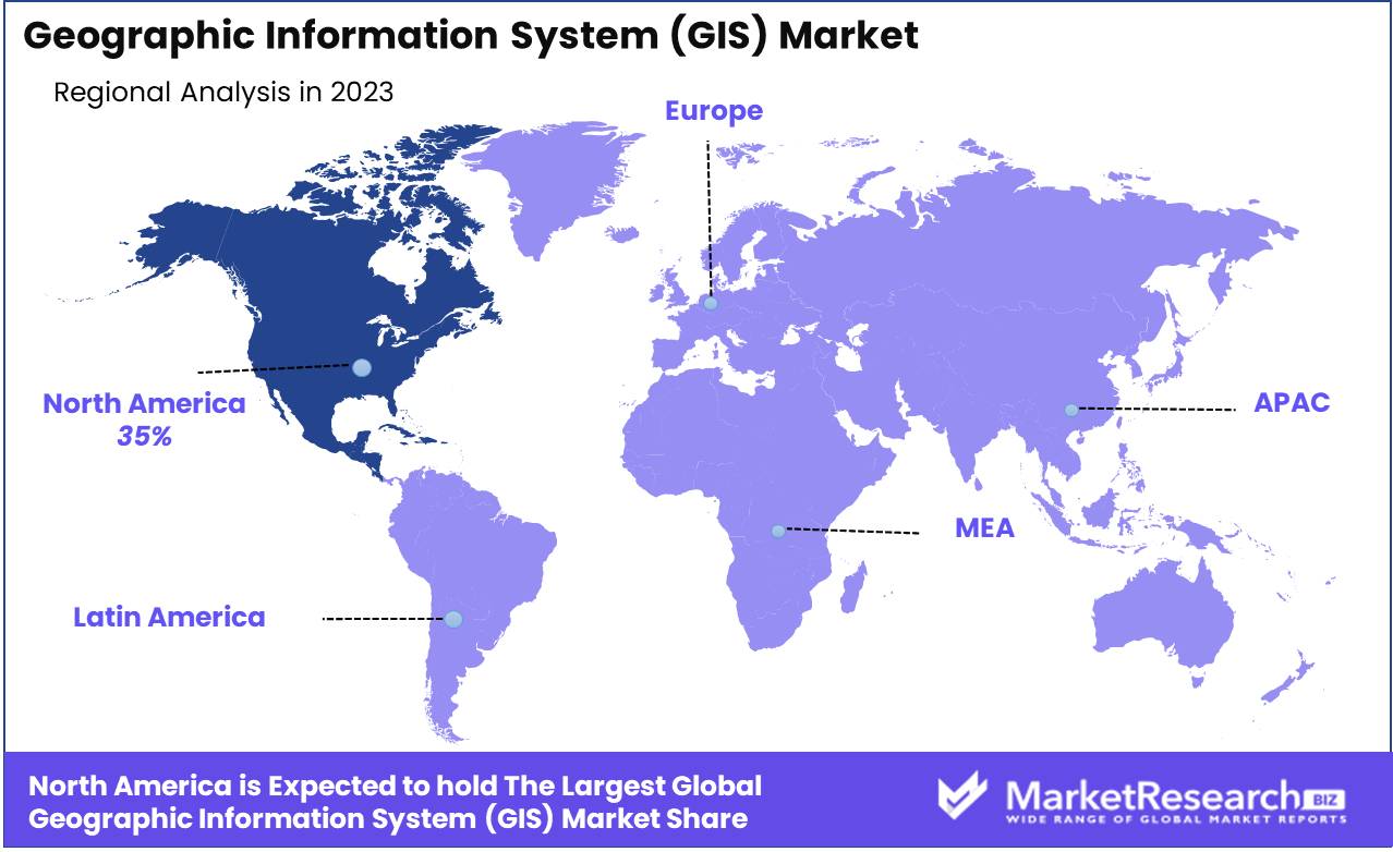
- Regional Dominance: North America holds a 35% market share, driven by advanced technology adoption and extensive geographical analysis needs.
- Growth Opportunity: Expanding GIS applications into emerging smart city projects offers a substantial growth avenue.
Driving factors
Increasing Use in Urban Planning and Infrastructure Development
The increasing use of Geographic Information Systems (GIS) in urban planning and infrastructure development is a significant growth driver for the market. GIS technology enables urban planners to analyze spatial data and visualize urban growth patterns, which is crucial for sustainable development. By integrating GIS with urban planning processes, cities can optimize land use, manage resources efficiently, and improve public services.
This integration is vital as urban populations continue to expand, necessitating sophisticated tools to handle complex planning and infrastructure challenges. Furthermore, governments and municipal authorities are increasingly adopting GIS to streamline operations and improve decision-making, further fueling market growth.
Growing Demand for Real-Time Geographic Data
The demand for real-time geographic data is growing rapidly, driven by the need for immediate and precise spatial information across various sectors. Real-time data acquisition allows for more effective monitoring, management, and response to dynamic situations, such as traffic management, environmental monitoring, and emergency response. Industries such as logistics, transportation, and utilities rely heavily on real-time GIS data to enhance operational efficiency and improve service delivery.
This demand is expected to rise as the Internet of Things (IoT) proliferates, connecting more devices and generating vast amounts of real-time spatial data, which, in turn, propels the growth of the GIS market.
Advancements in GIS Technology and Software
Technological advancements in GIS software and tools are pivotal in driving market growth. Innovations such as 3D GIS, cloud-based solutions, and mobile GIS applications have revolutionized the way spatial data is collected, analyzed, and utilized. These advancements have made GIS more accessible and user-friendly, encouraging wider adoption across various industries.
The integration of AI and big data analytics with GIS technology further enhances its capabilities, enabling more sophisticated data analysis and predictive modeling. As technology continues to evolve, the GIS market is likely to witness sustained growth, driven by continuous improvements and the development of new, advanced applications.
Restraining Factors
High Implementation Costs
One of the primary restraining factors for the GIS market is the high cost of implementation. Establishing a comprehensive GIS infrastructure involves significant investment in hardware, software, and skilled personnel. These costs can be prohibitive, especially for small and medium-sized enterprises (SMEs) and organizations with limited budgets.
High implementation costs may slow down the adoption rate of GIS technology, particularly in developing regions where financial resources are constrained. Overcoming this barrier requires innovative solutions, such as affordable GIS packages and subscription-based models, to make the technology more accessible and cost-effective.
Data Privacy and Security Concerns
Data privacy and security concerns pose significant challenges to the growth of the GIS market. The extensive use of GIS involves the collection and storage of vast amounts of sensitive geographic and personal data, making it a target for cyber-attacks and data breaches. Ensuring the security and privacy of this data is paramount to maintaining user trust and compliance with regulatory standards.
Organizations must invest in robust cybersecurity measures and adopt stringent data protection protocols to mitigate these risks. Addressing these concerns is crucial for the continued adoption and growth of GIS technologies.
By Component Analysis
Hardware held a dominant market position in the By Component segment of the Geographic Information System (GIS) Market, capturing more than a 60% share.
In 2023, Hardware held a dominant market position in the By Component segment of the Geographic Information System (GIS) Market, capturing more than a 60% share. This dominance is driven by the essential role of hardware components such as GPS devices, sensors, and computers in capturing, processing, and analyzing geospatial data. The increasing demand for advanced hardware to support high-precision mapping, data collection, and real-time analysis in various industries underpins its significant market share.
Software is also critical, providing the necessary tools for data analysis, visualization, and integration. Despite its importance, the market share for software is smaller compared to hardware due to the initial high costs and complexity of hardware procurement and deployment.
By Function Analysis
Mapping held a dominant market position in the By Function segment of the Geographic Information System (GIS) Market, capturing more than a 40% share.
In 2023, Mapping held a dominant market position in the By Function segment of the Geographic Information System (GIS) Market, capturing more than a 40% share. The significant market share is attributed to the fundamental importance of mapping in GIS applications across various sectors, including urban planning, environmental management, and infrastructure development. Mapping functions provide crucial spatial data and visualization, enabling detailed analysis and informed decision-making.
Surveying is another essential function, providing critical data for mapping and analysis. However, its market share is smaller compared to mapping due to the broader application scope and higher frequency of mapping activities.
Telematics Navigation supports transportation and logistics through real-time tracking and routing but holds a smaller market share due to its specific focus.
Location-Based Services are growing rapidly, especially in consumer applications, but their market share remains modest compared to core GIS functions like mapping.
By Device Type Analysis
Desktop held a dominant market position in the By Device Type segment of the Geographic Information System (GIS) Market, capturing more than a 65% share.
In 2023, Desktop held a dominant market position in the By Device Type segment of the Geographic Information System (GIS) Market, capturing more than a 65% share. This dominance is driven by the widespread use of desktop GIS software for detailed spatial analysis, data management, and map creation in professional and academic settings. Desktops offer robust processing power, large storage capacity, and comprehensive toolsets, making them ideal for complex GIS tasks.
Mobile GIS devices are increasingly important for field data collection and real-time analysis. However, their market share is smaller compared to desktop GIS due to limitations in processing power and the preference for desktops in detailed and large-scale spatial data analysis.
By End-User Analysis
Transport and Logistics held a dominant market position in the By End-User segment of the Geographic Information System (GIS) Market, capturing more than a 30% share.
In 2023, Transport and Logistics held a dominant market position in the By End-User segment of the Geographic Information System (GIS) Market, capturing more than a 30% share. This significant market share is driven by the critical role of GIS in optimizing transportation routes, managing logistics operations, and improving supply chain efficiency. GIS technology enables real-time tracking, route planning, and software asset management, which are essential for the transport and logistics sector. The increasing demand for efficient logistics solutions and the growth of e-commerce further bolster the adoption of GIS in this industry.
Agriculture leverages GIS for precision farming and resource management, but its market share is smaller compared to transport and logistics due to the specialized nature of its applications.
Construction uses GIS for project planning and management, while Mining and Geology employ GIS for exploration and resource mapping. Oil & Gas relies on GIS for exploration and pipeline management. Despite their importance, these sectors hold smaller market shares due to their specific needs and lower overall volume compared to transport and logistics.
Key Market Segments
By Component
- Hardware
- GIS collectors
- Imaging sensors
- LiDAR
- Total stations
- GNSS/GPS antennas
- Software
- Desktop GIS
- Server GIS
- Developer GIS
- Mobile GIS
- Remote Sensing Software
By Function
- Mapping
- Surveying
- Telematics Navigation
- Location-Based Services
By Device Type
- Desktop
- Mobile
By End-User
- Transport and Logistics
- Agriculture
- Construction
- Mining and Geology
- Oil & Gas
- Others
Growth Opportunity
Expansion in Smart City Projects
The ongoing expansion of smart city projects presents substantial growth opportunities for the GIS market in 2024. Smart cities rely on integrated technologies to enhance the quality of urban life, and GIS plays a crucial role in this ecosystem.
By providing spatial data analysis and visualization, GIS helps in efficient resource management, improved public services, and enhanced urban planning. Governments and urban planners are increasingly adopting GIS solutions to build sustainable and resilient cities, driving market demand.
Integration with AI and Big Data Analytics
The integration of GIS with AI and big data analytics is set to unlock new opportunities for market growth. AI algorithms can process vast amounts of spatial data to identify patterns and trends that were previously undetectable, leading to more informed decision-making.
Big data analytics allows for the handling and analysis of large datasets, providing deeper insights and predictive capabilities. This synergy enhances the functionality of GIS, making it an indispensable tool across various industries, from agriculture to urban planning.
Latest Trends
Use of GIS in Disaster Management and Response
The use of GIS in disaster management and response is a growing trend that will significantly impact the GIS market in 2024. GIS technology provides critical support in mapping hazard zones, planning evacuation routes, and coordinating emergency response efforts.
Real-time spatial data helps authorities and first responders make timely and informed decisions during disasters, potentially saving lives and reducing damage. The increasing frequency and severity of natural disasters highlight the importance of GIS in disaster preparedness and response, driving its adoption.
Cloud-Based GIS Solutions
Cloud-based GIS solutions are gaining traction as they offer enhanced flexibility, scalability, and cost-efficiency. By leveraging cloud technology, organizations can access GIS applications and data from anywhere, facilitating collaboration and data sharing.
Cloud-based GIS also reduces the need for significant upfront investment in hardware and software, making it more accessible to a broader range of users. This trend is expected to continue, with more organizations migrating their GIS operations to the cloud to take advantage of these benefits.
Regional Analysis
North America dominated the Geographic Information System (GIS) Market, capturing 35% of the market share.
In 2023, North America held a dominant position in the Geographic Information System (GIS) Market, capturing 35% of the market share. This leadership is driven by extensive adoption of GIS technologies across various sectors, including government, utilities, transportation, and healthcare. The United States and Canada are major contributors, benefiting from advanced technological infrastructure, significant investments in smart city projects, and strong demand for spatial data analytics to enhance decision-making processes.
Europe follows closely, driven by the increasing use of GIS for urban planning, environmental monitoring, and disaster management. The region's strong focus on sustainability and environmental protection also contributes to the growing demand for GIS solutions.
Asia Pacific is experiencing rapid growth in the GIS market, fueled by urbanization, infrastructure development, and the expansion of smart city initiatives in countries such as China, India, and Japan.
Middle East & Africa show promising potential, supported by rising investments in infrastructure and urban development projects, particularly in the UAE, Saudi Arabia, and South Africa. The adoption of GIS technologies in sectors such as oil and gas, construction, and utilities is gradually increasing.
Latin America is emerging as a growing market for GIS, with Brazil and Mexico leading the demand. The region benefits from improving technological infrastructure and increasing awareness of the advantages of GIS in sectors like agriculture, forestry, and disaster management.
Key Regions and Countries
North America
- US
- Canada
- Mexico
Western Europe
- Germany
- France
- The UK
- Spain
- Italy
- Portugal
- Ireland
- Austria
- Switzerland
- Benelux
- Nordic
- Rest of Western Europe
Eastern Europe
- Russia
- Poland
- The Czech Republic
- Greece
- Rest of Eastern Europe
APAC
- China
- Japan
- South Korea
- India
- Australia & New Zealand
- Indonesia
- Malaysia
- Philippines
- Singapore
- Thailand
- Vietnam
- Rest of APAC
Latin America
- Brazil
- Colombia
- Chile
- Argentina
- Costa Rica
- Rest of Latin America
Middle East & Africa
- Algeria
- Egypt
- Israel
- Kuwait
- Nigeria
- Saudi Arabia
- South Africa
- Turkey
- United Arab Emirates
- Rest of MEA
Key Players Analysis
The Geographic Information System (GIS) market is poised for significant growth in 2024, driven by advancements in geospatial technologies, increased demand for location-based services, and the integration of GIS with other emerging technologies like IoT and AI. Key players in this market are leading the charge through innovation, strategic acquisitions, and robust product offerings.
Environmental Systems Research Institute Inc. (Esri) remains a cornerstone in the GIS landscape, known for its comprehensive ArcGIS platform, which continues to set industry standards for geospatial analytics and mapping solutions. Esri's focus on enhancing user experience and integrating AI capabilities ensures its competitive edge.
Hexagon leverages its strong portfolio in geospatial sensors, software, and autonomous solutions, driving the convergence of physical and digital worlds. Its innovative approach to smart city solutions and infrastructure management positions Hexagon as a critical player in urban development projects.
Pitney Bowes Inc. offers robust location intelligence solutions that enhance customer engagement and operational efficiency. Their focus on e-commerce logistics and delivery services provides a unique niche in the GIS market.
Autodesk Inc. integrates GIS with Building Information Modeling (BIM), enabling enhanced infrastructure design and construction management. This integration facilitates better project visualization and planning, driving efficiencies in the AEC (architecture, engineering, and construction) sector.
Trimble Inc. continues to expand its geospatial offerings through advanced surveying solutions and GNSS technologies. Trimble’s focus on agriculture, construction, and transportation underscores its versatile applications of GIS.
Topcon and Hi-Target are pivotal in advancing precision agriculture and smart farming techniques, leveraging GIS to optimize resource use and crop yields.
Bentley Systems Incorporated excels in providing comprehensive infrastructure engineering software, facilitating the integration of GIS with digital twins to enhance asset performance and sustainability.
Caliper Corporation and Cadcorp are recognized for their innovative mapping and spatial analysis software, supporting diverse applications from urban planning to emergency response.
SuperMap Software Co. Ltd. is a prominent player in the Asia-Pacific region, known for its cutting-edge 3D GIS technology and big data analytics, expanding its global footprint.
L3Harris Technologies Inc. and Maxar Technologies dominate the satellite imagery and geospatial intelligence sectors, providing critical data for defense, environmental monitoring, and disaster response.
Market Key Players
- Environmental Systems Research Institute Inc. (Esri)
- Hexagon
- Pitney Bowes Inc.
- Autodesk Inc.
- Trimble Inc.
- Topcon
- Hi-Target.
- BENTLEY SYSTEMS IncORPORATED
- Caliper Corporation
- Computer Aided Development Corporation Limited (Cadcorp)
- SuperMap Software Co. Ltd.
- L3Harris Technologies Inc.
- Maxar Technologies
Recent Development
- In January, 2024: Hi-Target: Hi-Target launched a new line of affordable GIS devices tailored for educational institutions. Priced at $299 per unit, these devices have already been adopted by 500 universities and colleges worldwide, enhancing geospatial education.
- In January, 2024: Hi-Target: Hi-Target launched a new line of affordable GIS devices tailored for educational institutions. Priced at $299 per unit, these devices have already been adopted by 500 universities and colleges worldwide, enhancing geospatial education.
Report Scope
Report Features Description Market Value (2023) USD 12.1 Bn Forecast Revenue (2033) USD 39.5 Bn CAGR (2024-2033) 12.9% Base Year for Estimation 2023 Historic Period 2018-2023 Forecast Period 2024-2033 Report Coverage Revenue Forecast, Market Dynamics, Competitive Landscape, Recent Developments Segments Covered By Component (Hardware, Software), By Function (Mapping, Surveying, Telematics Navigation, Location-Based Services), By Device Type (Desktop, Mobile), By End-User (Transport and Logistics, Agriculture, Construction, Mining and Geology, Oil & Gas, Others) Regional Analysis North America - The US, Canada, & Mexico; Western Europe - Germany, France, The UK, Spain, Italy, Portugal, Ireland, Austria, Switzerland, Benelux, Nordic, & Rest of Western Europe; Eastern Europe - Russia, Poland, The Czech Republic, Greece, & Rest of Eastern Europe; APAC - China, Japan, South Korea, India, Australia & New Zealand, Indonesia, Malaysia, Philippines, Singapore, Thailand, Vietnam, & Rest of APAC; Latin America - Brazil, Colombia, Chile, Argentina, Costa Rica, & Rest of Latin America; Middle East & Africa - Algeria, Egypt, Israel, Kuwait, Nigeria, Saudi Arabia, South Africa, Turkey, United Arab Emirates, & Rest of MEA Competitive Landscape Environmental Systems Research Institute Inc. (Esri), Hexagon, Pitney Bowes Inc., Autodesk Inc., Trimble Inc., Topcon, Hi-Target., BENTLEY SYSTEMS IncORPORATED, Caliper Corporation, Computer Aided Development Corporation Limited (Cadcorp), SuperMap Software Co. Ltd., L3Harris Technologies Inc., Maxar Technologies Customization Scope Customization for segments, region/country-level will be provided. Moreover, additional customization can be done based on the requirements. Purchase Options We have three licenses to opt for: Single User License, Multi-User License (Up to 5 Users), Corporate Use License (Unlimited User and Printable PDF) -
-
- Environmental Systems Research Institute Inc. (Esri) (U.S.)
- Hexagon (Sweden)
- Pitney Bowes Inc. (U.S.)
- Autodesk Inc. (U.S.)
- Trimble Inc. (U.S.)
- Topcon (Japan)
- Hi-Target. (China)
- BENTLEY SYSTEMS IncORPORATED (U.S.)
- Caliper Corporation (U.S.)
- Computer Aided Development Corporation Limited (Cadcorp) (U.K.)
- SuperMap Software Co. Ltd. (China)
- L3Harris Technologies Inc. (U.S.)
- Maxar Technologies (U.S.)
Our Clients


View Our Licence Options
