Drone Analytics Market By Industry Type (Agriculture & Forestry, Construction, Insurance, Mining & Quarrying, Others), By Application Type (Thermal Detection, Geolocation Tagging, Others), By Type (On-Premise, On-Demand), By Solution Type, By Region And Companies - Industry Segment Outlook, Market Assessment, Competition Scenario, Trends, And Forecast 2023-2032
-
8807
-
June 2023
-
155
-
-
This report was compiled by Correspondence Linkedin | Detailed Market research Methodology Our methodology involves a mix of primary research, including interviews with leading mental health experts, and secondary research from reputable medical journals and databases. View Detailed Methodology Page
-
Report Overview
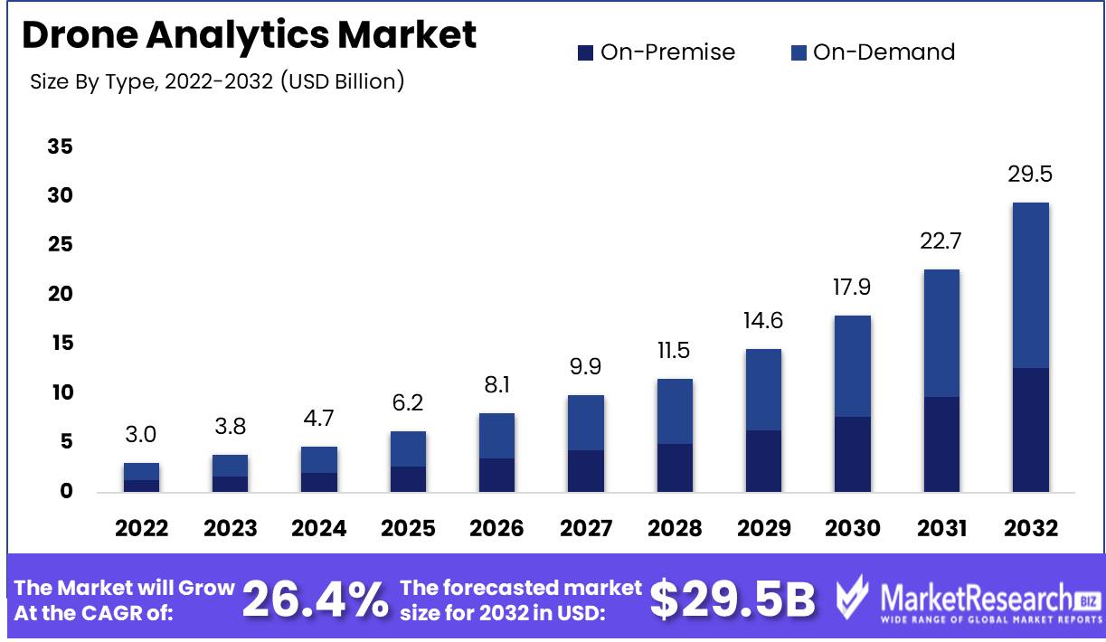
Drone Analytics Market size is expected to be worth around USD 29.5 Bn by 2032 from USD 3.0 Bn in 2022, growing at a CAGR of 26.4% during the forecast period from 2023 to 2032.
Over the past few years, the drone analytics market has expanded significantly. Due to its capabilities in the fields of surveillance and data collection, this technology has evolved as one of the most promising developments of this century. When combined with sophisticated software, drones can provide previously impossible insights. Innovative drone analytics software provides businesses with a bird's-eye view of their operations, granting them access to performance-enhancing data.
A drone is a remote-controlled, unmanned aerial vehicle. Drone analytics, on the other hand, is the use of software algorithms to extract meaningful insights from the copious amounts of data collected by drones. Drone technology has become a thrilling prospect for numerous industries and sectors, including agriculture, construction, the media, logistics, and even surveillance.
The primary objective of the drone analytics market is to offer businesses distinct insights into their operations without requiring substantial infrastructure investments. The technology can aid organizations in making better-informed decisions that positively impact their bottom line and corporate reputation. The use of drone analytics facilitates the collection of vital data and makes it simpler to access, analyze, and interpret.
The drone analytics market provides numerous benefits, such as cost savings, increased efficiency, enhanced precision, and enhanced safety. Using drones, enterprises can access inaccessible areas without endangering human life. The ability of drones to provide precise, near-real-time data is also a significant benefit in a variety of applications. In agriculture, for instance, drones can capture crop data to help farmers make better judgments regarding crop health, soil management, and irrigation.
The drone analytics market is expanding at a rapid rate, with a number of novel approaches emerging. Integration of artificial intelligence and machine learning algorithms, which can speed up data processing and analysis, is one such innovation. The use of sensors and high-quality cameras to collect data is also enhancing the sophistication of the drone analytics market.
Driving factors
More Drones
Due to its adaptability, efficiency, and cost-effectiveness, drone use has skyrocketed. Agriculture, construction, logistics, and defense utilize them more. Sensor-equipped drones may take high-resolution photos, videos, and geographical data for analysis and decision-making. For instance, drones are used in agriculture to monitor crops, estimate yields, and find pests, resulting in higher agricultural output and lower expenses. In construction, drones check, survey, and map sites, saving time and money. Drone data has expanded with drone use, fueling the drone analytics market.
Tech advances
The drone business has developed better sensors, cameras, and other technology, making drones more flexible and efficient. LiDAR, infrared, and multispectral sensors allow drones to acquire high-resolution photos and geographical data, improving data quality and precision. AI and machine learning systems can analyse and analyze enormous drone data sets to provide useful insights and decision-making. These advances have driven drone analytics market growth.
Data-Driven Decision-Making Demand
Agriculture, construction, and logistics are demanding data-driven decision-making. With drone data, it's important to get insights and make judgments. Drone analytics simplifies drone data processing and analysis, yielding actionable insights. Drone data may be utilized for site inspection, surveying, and mapping in the construction industry, resulting in informed decision-making and cost savings. In agriculture, drone data may be utilized for crop monitoring, yield estimate, and insect identification, increasing agricultural output and lowering expenses. Data-based decision-making has spurred drone analytics market growth.
Analytics software
Advanced analytics software and tools make drone data processing and analysis easier, increasing drone analytics services. Pix4D, Agisoft, and DroneDeploy have comprehensive data processing, analysis, and visualization functions. These software and technologies enable drone data analysis and decision-making. Cloud-based drone data processing technologies provide remote processing and analysis, improving productivity and lowering costs. Advanced analytics software and solutions have driven drone analytics market growth.
Restraining Factors
Airspace Rules
Many governments have tightened airspace restrictions due to drone popularity. Drones must be regulated by governments to protect public safety, national security, and privacy. Drone pilots must follow rigorous flight plans, altitudes, and geofencing rules. Many drone analytics market participants have been hampered by constraints and compliance requirements. The FAA's Part 107 regulations in the US are trying to make it simpler for enterprises, especially small ones, to enter the drone analytics market.
Privacy Issues
In the drone analytics market, privacy issues are another major restraint. Drones can capture audio and video, causing legal issues and public outrage. Surveillance drones have violated privacy and made people uncomfortable. Regulations are needed, but as drone technology advances, privacy rules should become clearer.
Flight Limitations
The restricted flight range of most drones limits their application in bigger projects. Most drones can only fly for a few hours, making them ineffective for long-term operations. Agriculture, maintenance, and security are restricted by flying capabilities. Hydrogen fuel cells and wireless charging systems are projected to improve drone battery life and flight endurance, making them more efficient and effective for a variety of applications.
Processing Problems
Drone analytics requires massive data gathering, processing, and interpretation, which is difficult. Processing massive amounts of data can be difficult without data management and processing tools. Weather, time of day, and surface roughness might affect drone data quality, especially during terrain-mapping. This affects data-based forecasts. Drones will increase data collecting and analysis accuracy. Investments, collaborations, and innovations can help firms find better analysis approaches that provide big dividends.
Industry Type Analysis
The use of drone analytics in various industries has been increasing rapidly in recent years, and the construction segment dominates the Drone Analytics Market. According to recent market research, the construction segment accounted for the highest market share in 2020. The construction industry involves a massive investment of money and time, and the use of drone analytics in constructing buildings, roads, and bridges helps in monitoring and analysis of construction projects, resulting in better planning, scheduling, and execution.
The consumer trend and behavior towards drone analytics in the construction segment are positive as the use of drone analytics in construction projects provides numerous benefits. The primary driver of this trend is the need for cost reduction and efficiency improvement. The adoption of drone analytics in construction projects offers a cost-effective solution that enables better planning, scheduling and execution, and remote monitoring. These benefits have resulted in an increase in the adoption rate of drone analytics in the construction industry globally.
Type Analysis
The on-demand segment dominates the Drone Analytics Market. On-demand drone analytics provides the flexibility of using drone services as per the requirement and eliminates the need for maintaining in-house drone fleet and personnel. On-demand drone services are particularly useful in the construction industry, where drones are now being used for monitoring building sites, mapping, surveying, and inspection of tall structures. The use of on-demand drone analytics in construction has simplified the construction project process and reduced cost and time investments for construction firms.
The consumer trend and behavior towards on-demand drone analytics are increasingly positive due to the flexibility it provides. The on-demand segment eliminates the need for maintaining an in-house drone fleet, resulting in cost savings for construction firms. In the forthcoming years, the on-demand segment in the Drone Analytics Market is anticipated to register the fastest growth rate. The rising need for cost-effective and efficient solutions for construction projects, coupled with the benefits provided by on-demand drone analytics, is driving the growth of the on-demand segment in the Drone Analytics Market.
Solution Type Analysis
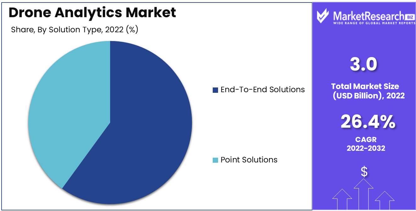
The end-to-end solutions segment dominates the Drone Analytics Market. The end-to-end solutions offer a complete solution for the automation of various processes in construction projects. These solutions include drone services, data analysis, and reporting, providing construction firms with actionable insights that enable them to optimize the construction project process.
The consumer trend and behavior towards end-to-end solutions in the Drone Analytics Market are increasingly positive as they offer a complete solution for the automation of various processes in construction projects. End-to-end solutions offer convenience, efficiency, and cost savings for construction firms. The use of end-to-end solutions in construction projects provides actionable insights that enable construction firms to optimize the construction project process. The end-to-end solutions segment in the Drone Analytics Market is anticipated to register the fastest growth rate.
Key Market Segments
By Industry Type
- Agriculture & Forestry
- Construction
- Insurance
- Mining & Quarrying
- Utility
- Telecommunication
- Oil & Gas
- Transportation
- Scientific Research
- Others
By Application Type
- Thermal Detection
- Geolocation Tagging
- Aerial Monitoring
- Ground Exploration
- Volumetric Calculations
- 3D Modeling
- Others
By Type
- On-Premise
- On-Demand
By Solution Type
- End-To-End Solutions
- Point Solutions
Growth Opportunity
Incorporation of AI and ML
Integration of artificial intelligence (AI) and machine learning (ML) technologies is one of the most significant factors driving the growth of the drone analytics market. AI and ML can automate the data analysis process, reduce errors, and increase the precision of results. As drones continue to collect massive quantities of data, the ability to efficiently process and analyze it is becoming more important than ever. The incorporation of AI and ML in drone analytics is anticipated to drive market growth, particularly as organizations seek to streamline operations and increase efficiency.
Increase in Application
There are numerous applications for drones, including infrastructure inspection, precision agriculture, mapping and surveying, and emergency response. In addition to an increase in the number of applications in which drones are utilized, the growth of drone analytics is also being fuelled by an increase in the number of applications in which drones are deployed. This has had a positive effect on operational efficiency and profitability.
Tools Specializing in Analytics
Availability of specialized analytics tools is an additional factor propelling development in the drone analytics market. These tools are designed expressly to process and analyze data captured by drones and provide more accurate and application-specific insights. The availability of sophisticated visualization tools, predictive analytics, and anomaly detection software also contributes to the expansion of the drone analytics market, as these tools expedite the data analysis process and improve the overall precision of the results.
Industry Partnerships
Collaborations between drone manufacturers, software providers, and data analytics firms are becoming more prevalent as the number of drone applications increases and the significance of data analytics grows. These collaborations permit the exchange of knowledge and data, which can lead to the creation of more precise and efficient analytics software. Collaborations also contribute to innovation, which can result in the development of new applications and the expansion of extant markets.
Latest Trends
Drone sensor advancements
Drone sensor technology has driven recent drone technological advancements. Drone sensors including thermal, LiDAR, multispectral, and high-resolution cameras are being developed. These sensors allow enterprises to acquire precise data quickly and accurately. Data analysis helps firms make better operational decisions.
Agriculture's Drone Analytics Use
Agricultural drones are popular. Agriculture uses drone analytics for crop monitoring, yield estimate, soil study, and more. Farmers may use drones with sensors and data analytics tools to gather agricultural data and make better decisions. Such insights can boost agricultural yields, save expenses, and boost profits. Drone analytics might revolutionize agriculture, making it more sustainable and efficient.
AI Drone Analytics Software Adoption
The drone analytics market has been transformed by AI. AI-based analytics software helps firms understand their data and make decisions based on advanced algorithms and predictive models. AI has made autonomous drones possible, improving data collecting. Companies will invest in AI-based drone analytics software as demand rises.
Drone-GIS Data Analysis
GIS and drones are being used to improve corporate operations. GIS technology collects and analyzes geographical data, providing insights about a location. Businesses may use drones and GIS to collect data and analyze it using smart software. This integration has created new drone applications in surveying, mapping, and environmental monitoring.
Regional Analysis
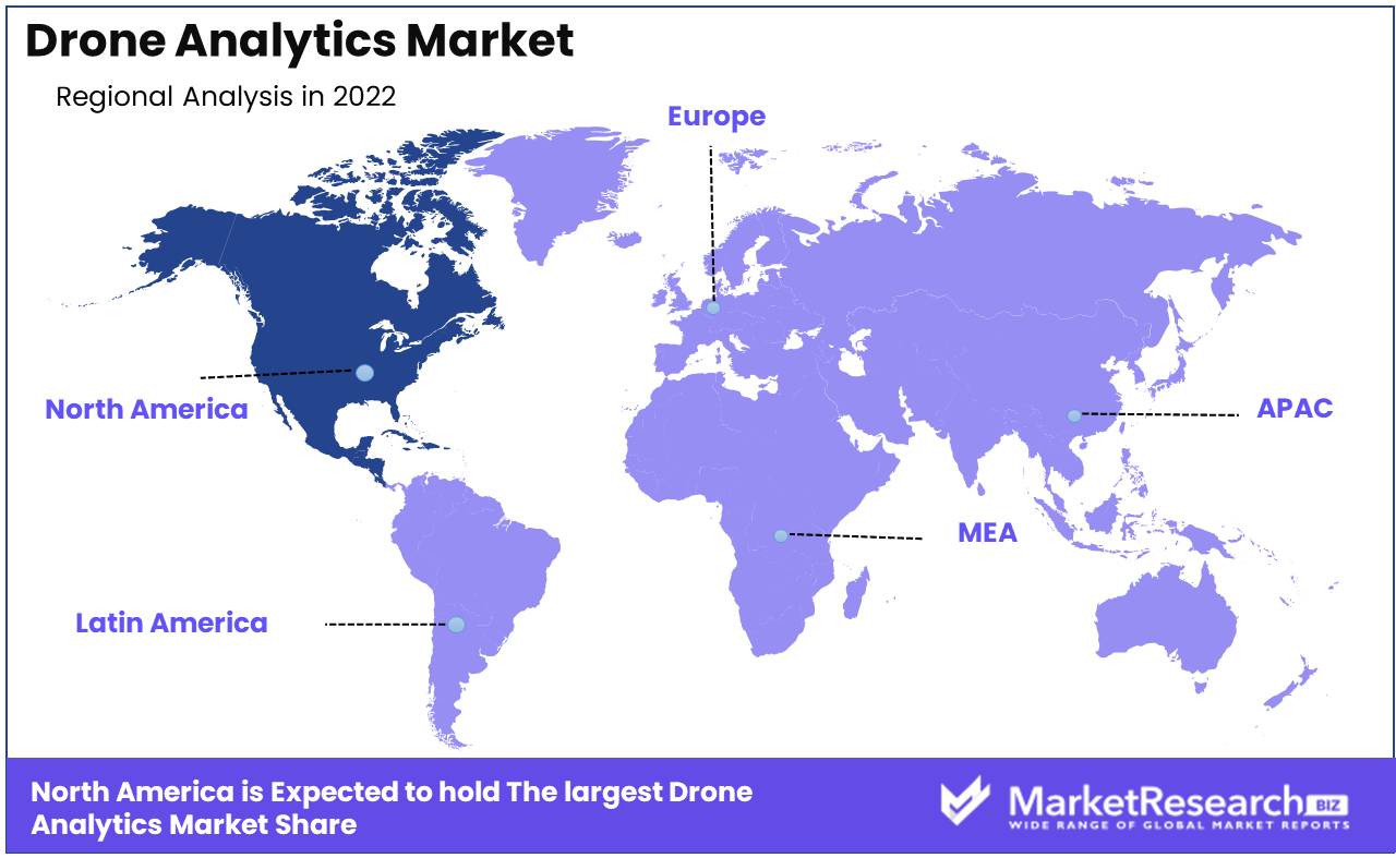
North America leads drone analytics. The usage of drones has transformed industries. Aerial imagery, crop scouting, search and rescue, and building site inspections use drones. Drone utilization has increased drone data across businesses. Analyzing and processing this data yields actionable insights that may guide decision-making and boost productivity.
The worldwide drone analytics market is expected to explode. North America dominates this market. This essay examines why North America dominates the drone analytics market.
Due to demand for drones and aerial data in agriculture, construction, energy, and utilities, North America dominates the drone analytics market. Due to high-resolution pictures, drones are becoming popular for aerial monitoring.
North America has fewer drone regulation than other regions. The FAA loosens commercial drone limitations in the US. This has pushed corporations to invest in drone technology and utilize drones in new sectors. This has grown the drone analytics market in the region.
Key Regions and Countries
North America
- US
- Canada
- Mexico
Western Europe
- Germany
- France
- The UK
- Spain
- Italy
- Portugal
- Ireland
- Austria
- Switzerland
- Benelux
- Nordic
- Rest of Western Europe
Eastern Europe
- Russia
- Poland
- The Czech Republic
- Greece
- Rest of Eastern Europe
APAC
- China
- Japan
- South Korea
- India
- Australia & New Zealand
- Indonesia
- Malaysia
- Philippines
- Singapore
- Thailand
- Vietnam
- Rest of APAC
Latin America
- Brazil
- Colombia
- Chile
- Argentina
- Costa Rica
- Rest of Latin America
Middle East & Africa
- Algeria
- Egypt
- Israel
- Kuwait
- Nigeria
- Saudi Arabia
- South Africa
- Turkey
- United Arab Emirates
- Rest of MEA
Key Players Analysis
Drones are being used in more sectors, driving the drone analytics market. Many players compete in the market. DJI, Parrot SA, Aerovironment Inc., PrecisionHawk, DroneDeploy, Agribotix LLC, Airware Inc., Delta Drone SA, and Honeywell International Inc. are some of the leading companies in the drone analytics market.
DJI dominates the drone market with a variety of devices. The firm offers drone analytics software that lets users record, interpret, and turn aerial data into actionable insights. Parrot SA, another drone analytics market leader, offers a variety of drones and data collecting and analytics software.
PrecisionHawk is a major drone solutions supplier for agriculture, energy, and insurance. The firm provides aerial data analytics software. Another contender in the drone analytics market is DroneDeploy, which provides a cloud-based platform for managing and analyzing drone data.
Agribotix LLC offers precision agricultural drone technologies to help farmers improve crop health and productivity. Airware Inc. provides end-to-end drone solutions for mining, construction, and insurance. Delta Drone SA provides drone-based solutions for numerous applications in France.
Honeywell International Inc., a global business, just joined the drone analytics market. The firm provides drone data management and analysis software for oil and gas, utilities, and environmental monitoring. Innovation and product expansion by these leading competitors are growing the drone analytics market.
Top Key Players in Drone Analytics Market
- Airware, Inc.
- DroneDeploy
- Delta Drone SA
- Pix4D SA
- PrecisionHawk Inc.
- AeroVironment, Inc.
- Viatechnik LLC
- Environmental Systems Research Institute, Inc. (Esri)
- AgEagle Aerial Systems, Inc. (Agribotix, LLC)
- Optelos
Recent Development
In 2022, Launched by DroneDeploy DroneDeploy Analytics enables users to easily analyze drone footage and data, uncovering valuable insights and empowering users to make decisions that promote development and efficiency.
In 2022, Pix4D also released its new drone analytics platform. Pix4Dmapper enables users to generate 3D models and maps from drone imagery, offering a comprehensive and precise view of any area.
In 2023, Airware's new product, Airware Insights, was introduced and allows drone operators to monitor and analyze drone operations. This all-encompassing platform promises to streamline the administration and compliance of drone operations.
Report Scope:
Report Features Description Market Value (2022) USD 3.0 Bn Forecast Revenue (2032) USD 29.5 Bn CAGR (2023-2032) 26.4% Base Year for Estimation 2022 Historic Period 2016-2022 Forecast Period 2023-2032 Report Coverage Revenue Forecast, Market Dynamics, COVID-19 Impact, Competitive Landscape, Recent Developments Segments Covered By Industry Type (Agriculture & Forestry, Construction, Insurance, Mining & Quarrying, Utility, Telecommunication, Oil & Gas, Transportation, Scientific Research, Others), By Application Type (Thermal Detection, Geolocation Tagging, Aerial Monitoring, Ground Exploration, Volumetric Calculations, 3D Modeling, Others), By Type (On-Premise, On-Demand), By Solution Type (End-To-End Solutions, Point Solutions) Regional Analysis North America – The US, Canada, & Mexico; Western Europe – Germany, France, The UK, Spain, Italy, Portugal, Ireland, Austria, Switzerland, Benelux, Nordic, & Rest of Western Europe; Eastern Europe – Russia, Poland, The Czech Republic, Greece, & Rest of Eastern Europe; APAC – China, Japan, South Korea, India, Australia & New Zealand, Indonesia, Malaysia, Philippines, Singapore, Thailand, Vietnam, & Rest of APAC; Latin America – Brazil, Colombia, Chile, Argentina, Costa Rica, & Rest of Latin America; Middle East & Africa – Algeria, Egypt, Israel, Kuwait, Nigeria, Saudi Arabia, South Africa, Turkey, United Arab Emirates, & Rest of MEA Competitive Landscape Airware, Inc., DroneDeploy, Delta Drone SA, Pix4D SA, PrecisionHawk Inc., AeroVironment, Inc., Viatechnik LLC, Environmental Systems Research Institute, Inc. (Esri), AgEagle Aerial Systems, Inc. (Agribotix, LLC), Optelos Customization Scope Customization for segments, region/country-level will be provided. Moreover, additional customization can be done based on the requirements. Purchase Options We have three licenses to opt for: Single User License, Multi-User License (Up to 5 Users), Corporate Use License (Unlimited User and Printable PDF) -
-
- Airware, Inc.
- DroneDeploy
- Delta Drone SA
- Pix4D SA
- PrecisionHawk Inc.
- AeroVironment, Inc.
- Viatechnik LLC
- Environmental Systems Research Institute, Inc. (Esri)
- AgEagle Aerial Systems, Inc. (Agribotix, LLC)
- Optelos


